10th -12th May
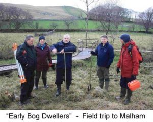
Again an absolutely fantastic weekend arranged by Bob Appleyard. 6 of us stayed at Malham Tarn Field Study Centre where we enjoyed good food, an honesty bar, well stocked reference library and each had comfortable rooms (most with en suite too!) Well worth a visit!
Rain on the Friday night meant an evening session in the classroom. Here Bob gave us the background geology to the area – Alston granite block underlying the Carboniferous limestone, unconformable Silurian Slates, inliers and glacial till with the North and Middle Craven Faults crossing the area. We were made to think hard about the depositional environments, especially of the limestone, and discussed possible reef formations, the Yoredale sequences and changing sea levels with some debate about deposition rates.
Saturday promised rain, so we shot up to Janet’s Foss & Goredale Scar (which I’d never visited). The massive Great Scar limestone gorge – in places covered with tufa – and the foss in full flow was amazing. Spring lines were very evident in the valley floor as the limestone met the underlying Silurian. Possible fault lines (within the limestone) were also noted in the landscape.
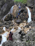
As the rain set in we had a very wet but enjoyable time identifying some mineral workings parallel to the mid-craven fault on Kirby Fell and fossicking about in the spoil heaps, finding galena, calamine (smithsonite), blue copper/azurite?, barytes and several unidentified black glassy pieces- possibly coal from nearby Fountains Fell.
After returning to the Field Centre to have lunch and dry out, we returned in the afternoon to Goredale Beck – above Janet’s Foss – to see if we could trace the line of the North Craven Fault on the ground for ourselves. Reef limestone was very evident just above the Foss where some lovely slickensides were also exposed. We could also see the steeply dipping Silurian slatey rock in the beck bed and on a farm track by a ‘ford’. Some distinct landscape & vegetation differences too; springs and fantastic yellowed calcite/tufa staining, but glacial till muddied the evidence. Altogether about 400m between the two rocks on the ground, but no clear ‘line’. On reflection, some of us realised with surprise (that we hadn’t thought of it before) that these massive fault-lines don’t show up well in the landscape.
Saturday evening we had another short evening session on the hydrology of the moss and how it can be measured – ready for our try-out on Sunday morning.
 This was at least dry, though there was a sharp wind. The local ranger took us out on the Moss’ boardwalk, but the cold and wet spring had put most flowers and insects well behind. So although we didn’t see a lot we were given a good insight into the ecological work of the centre and how the Moss is cared for – delivered with dry humour on occasion! We followed this with our surveying experiments, using the Field Centre equipment out on the moss itself– taking care where we walked on the VERY bouncy surface!
A quick lunch and ‘goodbye’ to the Field Centre as we set off to look at further landscape changes associated with the faults on our way to Settle. A brief stop to reduce cars and onto a really interesting reef formation Bob had discovered near to Scalebar Force – which is itself a fantastic and little known waterfall marking the distinct change/fault between limestone and shales. This area is well worth another visit – and we hope to go back. Research papers and googled information have been flying around!
As you can see a really varied programme and in spite of the weather a very enjoyable & stimulating weekend!
Ailsa Burrows